Martes, 16 de Abril de 2024
Punta del Este 12
80
Martes, 16 de Abril de 2024
80
 Atractivos
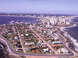
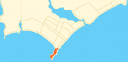
Punta de la Salina is the southernmost point of Uruguay.
Its name - meaning point of the salt mine - dates back to the old times when salt mining was the main commercial activity in the peninsula, and the reason for the first settlement.
The imaginary line between Punta Espinillo in Argentina and Punta de la Salina is considered the limit between the River Plate and the Atlantic Ocean.
Symbolically, there is a huge anchor from an English ship, but on a normal day one can see a cement point that marks the real southern end of the country.